So I recently went on a trip to Southern California. I took some pics and GeoTagged them when I got back. This is a feature that both Zooomr and Flickr have that lets you place your photos on a map so people can see where they were taken.
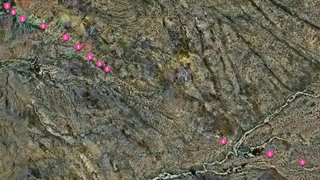
I GeoTagged all of my photos from my trip and you can see the whole thing or make it more interesting by looking at certain places. For example, here are all the pics I took in Disneyland. Or for even more fun here are the pics I took while on the Lost Palms Oasis trail in Joshua Tree National Park. (map above)
You can actually see the trail in the satelitte images. In the pic the sucession of images (the pink dots) are the trail I was on. It's fascinating because I can actually see little landmarks I remember on the map. See the other trail that crosses mine in the lower right of the pic? I remember walking through that (when you are actually in it its easy to get lost and take the wrong trail) and used it to figure out where my pics were taken and how far I actually traveled in relation to those. Right after the crossing trail you can see a dark spot. This was a grove of trees that I passed though and came out on the other side to the start of the sunset and a pretty young cactus.
Zooomr uses Google Maps and Flickr uses Yahoo. Yahoo has much much more detailed images of rural areas so it is better for us Nevadans. Googles are better in urban areas and all of California. One neat side note is that they both have amazing images of Burning Man. Yahoo! has sat pics as the event is occuring (double-click map to really zoom in!). But Google's is even more interesting. The Burning Man event was actually moved slightly this year to help reduce desert scarring. On Googles map you see both an image from a previous year when it was being built AND an image from this year while it is occuring! (I better save that one in case they fix it). I wonder if they purposefully take a pic during the event.
For even more GeoTagging ideas check out the Flickr blog. They have geotagged maps like lighthouses of the great lakes, all the pics tagged with self-portrait, pics of the tube in London, etc.
P.S. Also, to check out one of the coolest sat images yet, Google's new pic of the Eiffel Tower
1 comment:
I think you should get paid for this. figure out how you can get paid to blog about interesting shit. seriously. you're assignment is to spend some time figuring out if there are actual jobs that pay you to blog about interesting stuff. ok. good.
Post a Comment